Four communities across London took part in a month long citizen science project supported by Mapping for Change. The aim of ‘Clean Up London Air’ was to monitor and map Nitrogen Dioxide (NO2) pollution levels in both quiet residential areas selected by the local residents and adjacent roads with heavy passing traffic during the month of July. The four areas involved in the project, Latimer Road, Camden, Islington and Crystal Palace can be viewed on the Air Quality Community Map.

Camden
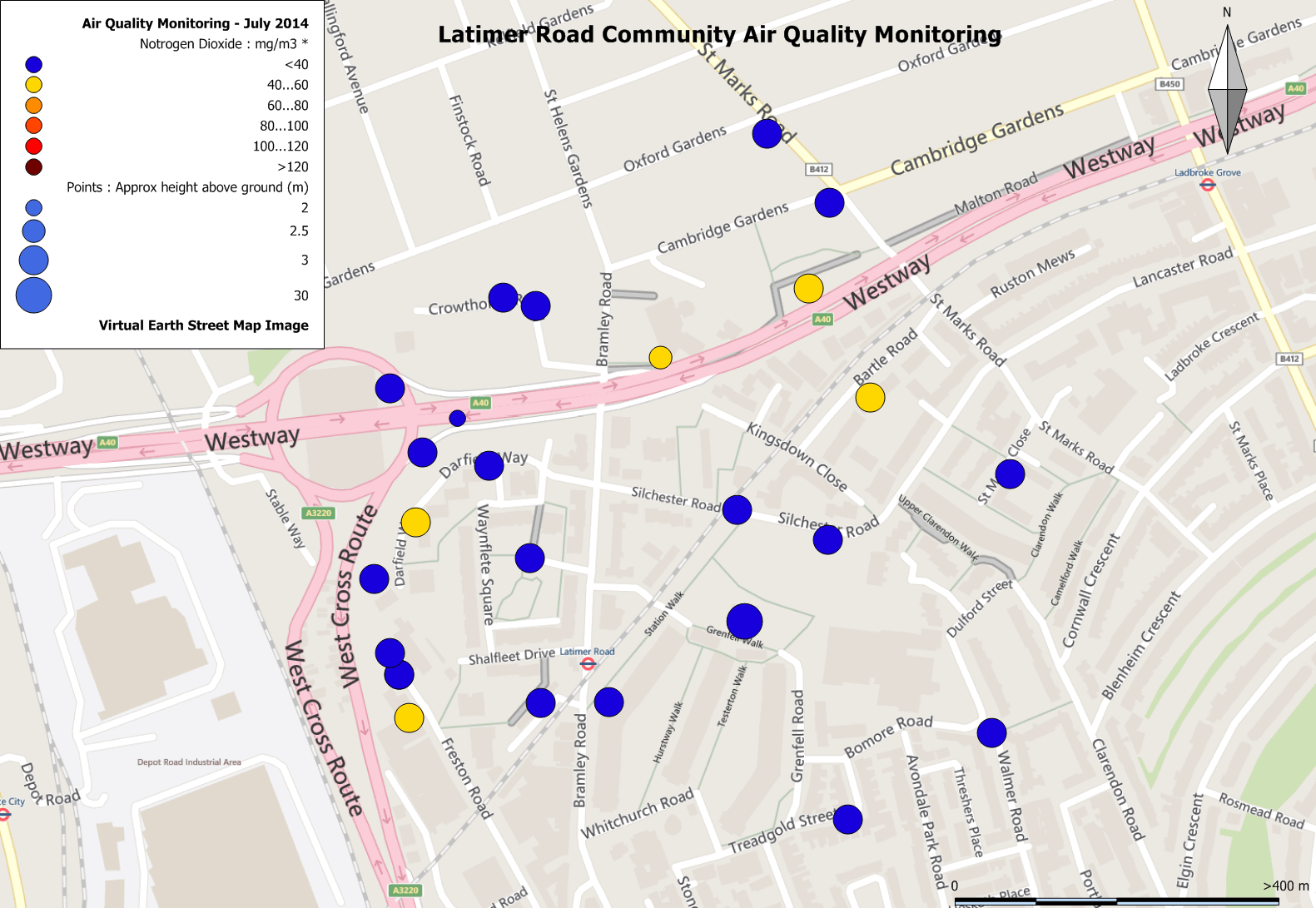
The results of the month long project have been eye opening to say the least. The highest measurements were recorded in Camden at the junction between Delancey Street and Camden High Street; a busy junction, with multiple bus routes and not far from the tube station. NO2 levels averaged 106.37µg/m3 over the course of the month, more than twice the European legal standard for the annual mean (40µg/m3). This is a major contrast to the more quite residential areas away from the busy roads such as Gloucester Crescent which had a reading of 24.5µg/m3. Similar patterns were recorded in Crystal Palace and Islington. The community in Latimer Road, situated alongside the A40 Westway, recorded the lowest readings on average across the four communities. This may be in part due to the morphology of the area, which sits several meters below the Westway.
Each of the four communities had their own reasons for taking part. In the 1900s, Crystal Palace was marketed as a “fresh air suburb”, high up above the valley fogs and with prevailing winds from the south coast. But today it is clogged with traffic and a major bus interchange. Tom Chance a resident had this to say about the project “we wanted to know just how bad the current pollution was, and whether those prevailing winds are still of any use. The local community has also repeatedly fought off proposals to build major commercial developments on our park, and traffic is always one of the main local worries. With another proposal on the cards from Boris and Chinese developers, we thought it would be a really good time to get an independent snapshot of the area”.
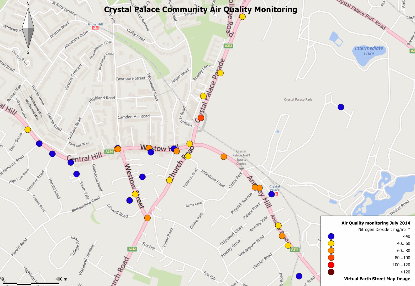
Crystal Palace
“The third reason for wanting to do the project was the ‘five borough problem‘. Crystal Palace sits at the boundary of five, yes five, different boroughs. None of them do any air quality monitoring around the traffic-heavy town centre, and a continuous air quality monitoring station in the area was closed a few years back due to budget cuts. So why not get our own monitoring going?”
Tom initiated the project after seeing the results from the No 2 Silvertown Tunnel group. “We have lots of active groups and people in the area, so I quickly enlisted the interest of some people from the local Transition Town, Green Party, and early-days Neighbourhood Forum. From a post to a Facebook group we also got the help of somebody who does similar work for her day job! She was able to show us how to set up the tubes, and gave us lots of useful info about air pollution.”
It is now clearly established, by doctors and health authorities, that NO2 is a major cause of otherwise avoidable death. Martin Sheppard, who worked on the Camden project explains that the levels in Camden, and especially along the Euston Road, are already well above the legal limits set out by European directives.
“Against this background, the Government’s plans for HS2 in Camden represent a major additional threat. Turning the heart of Camden into a building site for up to twenty years, with thousands of additional lorry journeys on a daily basis, is bound to increase the already illegal levels of NO2 pollution. By pressing ahead with HS2, the government will endanger the lives of Camden’s citizens and will be directly responsible for any additional deaths caused by the increased NO2 pollution level’.”
“Rather than simply relying on these generally clear facts, it is important for those wishing for a reduction in NO2 levels, and to demonstrate the unacceptability of the government’s plans for HS2 in Camden, to rely on up-to-date scientific measurements of the current and future threats. That is why Catherine Colley and I were delighted to take the opportunity of the grant offered by Mapping for Change to produce an NO2 and other pollutants map of an area certain to be affected by HS2’s plans: a triangle based on Delancey Street, Parkway and Camden High Street. It will be of great use to us when we appear before the Select Committee on HS2 currently sitting.”
Latimer Road Map
The Westway / A40 flyover runs adjacent to an estate on Latimer Road, where football pitches have been built to replace the green space lost to a new school. Marco Picardi wanted to take part in the project because the road’s traffic is increasing with the large scale residential and commercial developments that are being built in the White City Opportunity Area to the west. The emissions and brake dust look set to worsen with the diesel powered vehicles needed to transport heavy loads to the construction sites, and this will be followed by thousands more residents and businesses in the are using the road. With the local loss of green space to help balance out the pollution, residents are concerned about their wellbeing. In this context, Green Westway now wants to work with all local stakeholders to explore a series of measures to reduce the exposure of these spaces to pollution
Similarly, residents in Islington felt that they suffered high pollution levels, as much of London’s traffic passes through the St Peters neighbourhood on the New North Road.
Joe who took part in the Islington part of the project said “mapping and recording data is the first step to improving air quality in our area. Once we have gathered data we will communicate it through our quarterly newsletter to residents but also use it to lobby our local councillors and MP to do more to reduce the amount of road traffic pollution in our area. Without this mapping it’s hard to argue a case.”
Tom Chance who is part of the project in Crystal Palace said “now we have the results, we need to work out the next steps“. The pollution on side roads seems relatively safe with streets such as Versalles Road measuring 20.46µg/m3, but most of the main roads had readings that exceed annual legal limits, such as Crystal Palace Parade which had a measurement of 81.16µg/m3 and Royal Albert Pub Garden measuring 69.26µg/m3. Tom feels that one option would be to lobby TfL to clean up the sixteen bus routes that go along those main roads in Crystal Palace. “We’re also thinking of raising the cash to place a handful of tubes in some of the locations for a full twelve months, to get more accurate results.”
Similar results were returned from the Latimer Road and Islington projects. Upper Road in Islington which is near the High Street and next to a busy junction had a reading of 76.13µg/m3. Readings taken from a diffusion tube placed on a traffic light on Essex Road, near the High Street, came back at 87.93µg/m3, while readings from Cruden Street, a quiet residential street near to the City of London Academy, were 24.88µg/m3.
It’s clear to see that the results from the Clean Up London Air project raise a few questions with regards to the current NO2 levels in London. Every area tested had NO2 levels that breach the European annual average limits and with projects such as the HS2 under-way it seems inevitable that these may are set to increase even more.
Northwoods Voice is a local community based group campaigning against a large TfL proposed development in the centre of our town (Northwood – in the London Borough of Hillingdon). As part of this campaign we have been measuring Nitrogen Dioxide levels in our high street (named Green Lane) and have been finding results already today in excess of the annualised 40 ug/m3 EU legal limit. We have advised our local Council Officers and MP of these findings.